AWS for Industries
HxDR: Transforming geospatial data in the cloud with AWS and Hexagon
Architects, builders, engineers, surveyors, and related professionals who rely on reality capture tools and data can significantly reduce costs, reduce time, and make better decisions by using precise and readily available geospatial information for project planning and execution. To provide better access to spatial data, Hexagon announced HxDR, an AWS cloud-based digital reality visualization platform.
HxDR creates accurate, real-world digital representations of cities, buildings, structures, and landscapes through a seamless combination of reality capture data from airborne, ground, and mobile sensors such as LiDAR and photogrammetry. Users can then leverage complete, accurate, and precise digital twins of real-world locations, structures, and buildings to visualize and share their 3D design projects and models in a real-world context.
Professionals can use HxDR to access precise real-world spatial data for project design and to show their clients immersive 3D visualizations that can help drive decision-making. However, there are many situations where the digital spatial information isn’t concise or accessible, or it simply doesn’t exist.
Fortunately, new reality capture products make it much easier for AEC and survey professionals to get spatial data that doesn’t exist. Yet creating a digital reality from spatial data as a mesh of the existing original data and scanned data, which builds a digital twin of real-world locations and structures, leads to several challenges:
- It takes significant computational resources to create such a mesh and digital twin. The computational resources grow quickly with the size of the model or the complexity of the data.
- Storing and making this data available is demanding due to the amount of data. It starts with gigabyte-sized files and it ends with archives at a terabyte- and petabyte-sized space.
- Obtaining the data is expensive with individuals, scanning/surveying teams, automobiles, or airplanes used to capture the data with a variety of sensors. Repeating the data capture can also be expensive.
- Large amounts of data have to be securely stored and ready for on-demand post processing.
Another challenge is that multiple teams in multiple places must collaborate remotely. The data capture technicians and the construction or infrastructure professionals will most likely work at different locations around the globe.
How can HxDR and AWS services solve this challenge?
AWS services provides the tools needed to build an ambitious platform like HxDR and solve the challenges that it proposes: storage services and elastic compute cloud.
Amazon Simple Storage Service (Amazon S3) is the ideal place to manage the data for HxDR:
- Amazon S3 users can store any amount of data on-demand. Amazon S3 can cope with terabytes of data in all regions of the world.
- Amazon S3 safely stores the data and allows fine-grained access control to the data.
- Amazon S3 offers many ways to ingest data from data captures: using an internet upload, devices for an asynchronous transfer, or AWS Ground Station to stream satellite data into Amazon S3.
AWS compute services such as Amazon Elastic Compute Cloud (Amazon EC2), Amazon Elastic Kubernetes Service (Amazon EKS), AWS Fargate, and AWS Lambda offer dynamic on-demand compute capabilities. Data post-processing of the geospatial data from multiple sensors and sources can happen on demand and in parallel. This dynamic data processing capability helps end users get the data visualized when they need it. Resources are allocated on demand, so no local resource pools or lengthy request approvals are needed.
What types of sensors, data, and software processing are used for HxDR?
HxDR customers use data captured by a wide range of scanners, including tripod-based laser scanners, mobile and handheld laser scanners, and airborne hybrid scanners like the Leica City-Mapper-2 to scan entire landscapes, towns, and cities while in flight with high degrees of accuracy and detailed visualization.
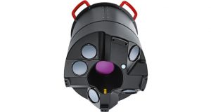
For example, HxDR customers can use devices like the BLK2GO, a new handheld imaging laser scanner from Hexagon for surveyors and other reality capture professionals, to scan buildings, structures, or other spaces and objects. Then they can add their own data to the platform, including BIM and CAD models. They can also use data uploaded by other HxDR customers and use data provided by Hexagon.
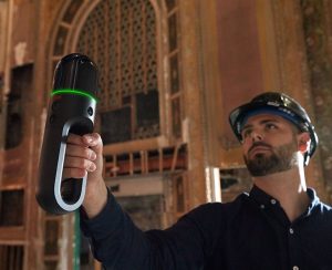
The innovative BLK2GO scanner generates files of an average size of 5 GB that are uploaded to Amazon S3. Customers are no longer bound to the capacity of disks they have in their office and can work remotely with precise digital twins streamed from the cloud. HxDR then uses the files in Amazon S3 jointly with microservices in a Kubernetes cluster on AWS to generate integrated views like the one below.
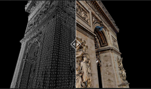
Amazon S3 stores the post-processed files that are then made available to customers on demand.
These solutions from HxDR and AWS can help many types of reality capture professionals, especially AEC companies and reality capture service providers, efficiently perform 3D visualizations in terms of cost and resources. With storage and elastic compute services from AWS, customers can store and manage vast amounts of data for 3D modeling.
The HxDR service is currently in a beta phase. Apply here to become a beta tester.
Learn more about how AWS is enabling innovation for manufacturing