AWS Physical AI Blog
Building Inspection Intelligence with AWS Spatial Data
A practical guide to spatial data management for inspection workflows on AWS
Introduction
Across industries, inspection teams are under increasing pressure to document asset conditions accurately, support compliance requirements, and maintain records that remain meaningful months or even years after data is captured.
In practice, many inspection programs generate large volumes of imagery and observations that are difficult to reuse beyond their original reporting purpose. As time passes, loss of context, inconsistent metadata, and unclear provenance can limit the ability to interpret prior findings or apply new analytical techniques.

This post explores how Spatial Data Management on AWS (SDMA) can be used to structure inspection outputs so they remain interpretable, auditable, and analytically useful over time, supporting a broad range of inspection workflows without prescribing a specific application or operating model.
A Spatial Data Approach
One way to increase the durability of inspection records is to treat inspection outputs as spatially referenced data, rather than as standalone files or reports.
When each inspection artifact is associated with a defined physical location, whether that location represents a component, segment, zone, or asset, inspection data becomes easier to compare, revisit, and analyze. Teams gain the ability to support comparison across different points in time, where issues are recurring, and which areas may require proactive attention.
Over time, this approach preserves the contextual integrity of inspection data, allowing organizations to revisit historical conditions, respond to new regulatory or operational questions, and apply updated analytical methods without re‑structuring how data is stored.
Spatial Data Management on AWS (SDMA)
Spatial Data Management on AWS (SDMA) provides a set of architectural patterns and managed services for organizing and governing spatially referenced data across the lifecycle of physical assets.
For inspection workflows, SDMA commonly supports:
- Ingestion of field‑generated imagery, observations, and sensor outputs
- Association of inspection artifacts with spatial identifiers and metadata
- Centralized storage with governance and access controls
SDMA does not prescribe how inspection teams structure their applications or roles. Instead, it provides a consistent data foundation that can support a wide range of interaction patterns, operating models, and organizational boundaries.
The primary benefit is not a specific workflow, but data stability: inspection artifacts remain linked to their physical context, retain provenance, and can be queried as requirements evolve.
Solution Architecture
Architecture Summary
- User Interaction and Application Layer
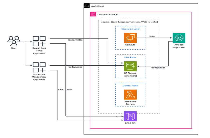
Inspection programs typically involve multiple interaction surfaces, ranging from lightweight field experiences used during data capture to more robust environments for review, analysis, and reporting. Rather than defining fixed application boundaries, Spatial Data Management on AWS (SDMA) supports these interaction surfaces through APIs and managed services that decouple how users interact with inspection data from how that data is stored and governed. SDMA includes the Spatial Data Portal, a web and desktop application for managing spatial assets, along with APIs that support integration with custom applications and workflows. - API-Driven Integration
All application interactions with the spatial data platform are mediated through a REST API hosted within the customer’s AWS account. The API layer provides a consistent and secure interface for reading and writing inspection data, spatial metadata, and related assets, and enforces separation between client applications and backend services. - Integration Layer (SDMA Compute)
Within the SDMA architecture, a dedicated integration layer provides compute services responsible for request handling, orchestration, validation, and business logic. This layer processes API requests from client applications and coordinates access to the underlying data and control planes. - AI Inference Workflow
Automated defect detection and classification are performed using Amazon SageMaker hosted inference endpoints. When inspection imagery is submitted or updated, the SDMA integration layer invokes the SageMaker endpoint with references to the relevant image assets stored in Amazon Simple Storage Service (Amazon S3). SageMaker applies custom computer vision models to analyze inspection imagery and identify anomalies or conditions of interest, returning structured results such as classification labels, confidence scores, and localization data. These results are then re‑ingested into SDMA as first‑class, spatially indexed inspection artifacts. - Data Plane (System of Record)
Spatial assets, inspection imagery, documents, and derived artifacts are stored in Amazon S3, which acts as the durable data store for the platform. The data plane supports high throughput reads and writes from multiple applications while maintaining a single, authoritative system of record for spatially indexed content. - Control Plane (Serverless Services)
The control plane consists of serverless services — including AWS Lambda — that manage workflows, metadata updates, and operational logic. These services coordinate how spatial data is registered, updated, and accessed, enabling consistent handling of inspection records and spatial relationships across applications.
Why This Architecture Works
Inspection workflows pull the system in different directions. In the field, teams need quick confirmation that they captured the right areas and that the images are usable. Back at the office, the priorities shift to keeping data intact over time and being able to look back, rerun analysis, and understand how conditions have changed across sites and inspections.
SDMA supports both sides of that equation by keeping spatial context consistent from capture through reporting. Images, metadata, and analysis results all reference the same locations, which makes the system easier to scale and far easier to reason about as portfolios grow.
Better AI Starts with Better Spatial Data
Many analytics and machine learning workflows depend on consistent and well‑structured input data. In inspection workflows, that does not come from labeled images alone. It comes from precise spatial context, consistent defect definitions, and a clear record of where findings came from and how they have changed over time.
SDMA enforces this discipline by tying every image, observation, and finding back to an explicit spatial reference. That structure removes much of the ambiguity that typically creeps into inspection datasets as teams, tools, and vendors change. With a shared spatial framework in place, teams can work more consistently across regions, compare conditions from one inspection cycle to the next, and train models on data that already reflects how physical assets are organized.
Because inspection artifacts are stored with stable spatial identifiers and metadata, downstream consumers can reliably query, aggregate, and analyze inspection data without transforming or re‑normalizing it. This shifts inspection data to a reusable analytical asset.
Inspection systems must support both automated inference and expert review because inspection findings frequently carry regulatory, financial, and safety implications. SDMA supports this by preserving model outputs, reviewer actions, and decision lineage as part of the same spatial record, allowing organizations to understand not just what a model predicted, but how a conclusion was reached.
Get Started with AWS Spatial Data Services
Ready to bring spatial intelligence to your inspection workflows? Explore the following AWS resources to learn more and begin building:
- Amazon SageMaker Documentation – Build, train, and deploy custom machine learning models for defect detection and image classification at scale.
- AWS IoT Services – Connect field inspection devices and drones to the cloud for real-time data capture and edge processing.
- AWS Architecture Best Practices – Review reference architectures and Well-Architected guidance for building reliable, scalable spatial data platforms.
To learn more about implementing spatial data workflows on AWS, visit the AWS Architecture Center or contact your AWS account team.
Conclusion
By treating inspection outputs as governed, spatially referenced data, organizations can preserve interpretability, support repeatability, and respond to future needs without reworking foundational data structures.
SDMA provides a flexible foundation for this approach, allowing inspection teams to evolve their workflows, tools, and analytical methods while maintaining continuity and accountability in their inspection records.