AWS Public Sector Blog
Accessing NOAA’s GOES-R Series Satellite Weather Imagery Data on AWS
Data from the National Oceanic and Atmospheric Administration’s (NOAA) Geostationary Operational Environmental Satellites (GOES)-R series satellite is available on Amazon Simple Storage Service (Amazon S3). Access it here at no cost.
NOAA operates a constellation of Geostationary Operational Environmental Satellites to provide continuous weather imagery and monitoring of meteorological and space environment data for the protection of life and property across the United States. GOES satellites provide critical atmospheric, oceanic, climatic, and space weather products supporting weather forecasting and warnings, climatologic analysis and prediction, ecosystems management, safe and efficient transportation, and other national priorities.
GOES satellites continually view the continental United States, Pacific and Atlantic Oceans, Central and South America, and Southern Canada. To fully cover Alaska, Hawaii, the entire continental United States and the Pacific and Atlantic Oceans (for tropical storms), NOAA operates two GOES satellites simultaneously: GOES-East and GOES-West. The satellites provide advanced imaging with increased spatial resolution, 16 spectral channels, and up to 1 minute scan frequency for more accurate forecasts and timely warnings.
The real-time feed and full historical archive of original resolution Advanced Baseline Imager (ABI) radiance data (Level 1b) and full resolution Cloud and Moisture Imager (CMI) products (Level 2) are freely available on Amazon S3 for anyone to use.
The availability of GOES-R Series data on AWS is the result of the NOAA Big Data Project (BDP) to explore the potential benefits of storing copies of key observations and model outputs in the cloud to allow computing directly on the data without requiring further distribution. This approach could help form new lines of business and economic growth while making NOAA’s data more easily accessible to the public.
About the Data
- Source: National Oceanic and Atmospheric Administration
- Category: Earth Science, Sensor Data, Natural Resource, Meteorological
- Format: netCDF v4
- License: There are no restrictions on the use of this data.
- Storage Service: Amazon S3
- Location: s3://noaa-goes16 in us-east-1 region
- Update Frequency: New data is added as soon as it’s available
If you have a research project that could take advantage of GOES data on AWS, you can apply for Earth on AWS Cloud Credits for Research.
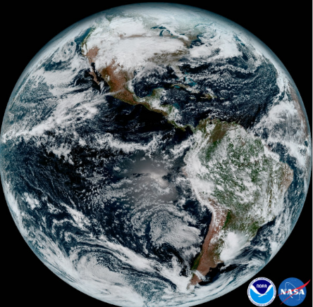
About the image: This composite color full-disk visible image is from 1:07 p.m. EDT on January 15, 2017 and was created using several of the 16 spectral channels available on the GOES-16 Advanced Baseline Imager (ABI) instrument. The image shows North and South America and the surrounding oceans. GOES-16 observes Earth from an equatorial view approximately 22,300 miles high, creating full disk images like these, extending from the coast of West Africa, to Guam, and everything in between.