DCS Spatial Services Modernizes on AWS, Speeds Up Emergency Imagery Processing from 4 Days to Under 22 Hours
Discover how this New South Wales government agency transformed its spatial data systems to improve agility, accelerate emergency response, and enhance public service delivery.
Overview
The NSW Department of Customer Service Spatial Services (DCS Spatial Services) provides trusted spatial data that powers emergency response, urban planning, and government services for over eight million residents. As NSW’s authoritative source of geospatial information, it delivers foundational data, including land boundaries, place names and elevation models, to help agencies make informed decisions that shape infrastructure, public safety, and disaster recovery efforts. DCS Spatial Services Foundational Spatial Data Framework is recognized as a core State Digital Asset, serving as the baseline for all government agencies within NSW. This designation streamlines data sharing across departments, facilitating coordination and decision-making.
DCS Spatial Services faced dual challenges: delivering emergency aerial imagery within 24 hours during disaster events, a response to recommendations from major disaster inquiries, as well as modernizing aging on-premises infrastructure. In response, the agency launched an Amazon Web Services (AWS) Cloud Modernization initiative that included a rapid response imagery and LiDAR processing system. Recognized with the 2024 DCS Excellence Award for Innovation, this system set a new standard for government innovation at scale. The initiative delivered a secure, resilient platform that bolstered emergency response, improved community safety, and enhanced operational agility while providing greater cost transparency. With AWS, DCS Spatial Services demonstrated how government agencies can partner with cloud technology to deliver mission-critical services and build future-ready digital capabilities.
About NSW Department of Customer Service Spatial Services
The NSW Department of Customer Service Spatial Services (DCS Spatial Services) provides trusted spatial data that powers emergency response, urban planning, and government services for over eight million residents. As NSW’s authoritative source of geospatial information, it delivers foundational data, including land boundaries, place names, and elevation models, to help agencies make informed decisions that shape infrastructure, public safety, and disaster recovery efforts. DCS Spatial Services Foundational Spatial Data Framework is recognized as a core State Digital Asset, serving as the baseline for all government agencies within NSW. This designation streamlines data sharing across departments, facilitating coordination and decision-making.
Opportunity | Overcoming Infrastructure Limitations for Faster Emergency Response
As demand for real-time geospatial data increased, DCS Spatial Services sought ways to process and deliver spatial data faster to support emergency response and government services. This need was reinforced by recommendations from the 2020 NSW Bushfire Inquiry, the Royal Commission into National Natural Disaster Arrangements, and the 2022 NSW Flood Inquiry.
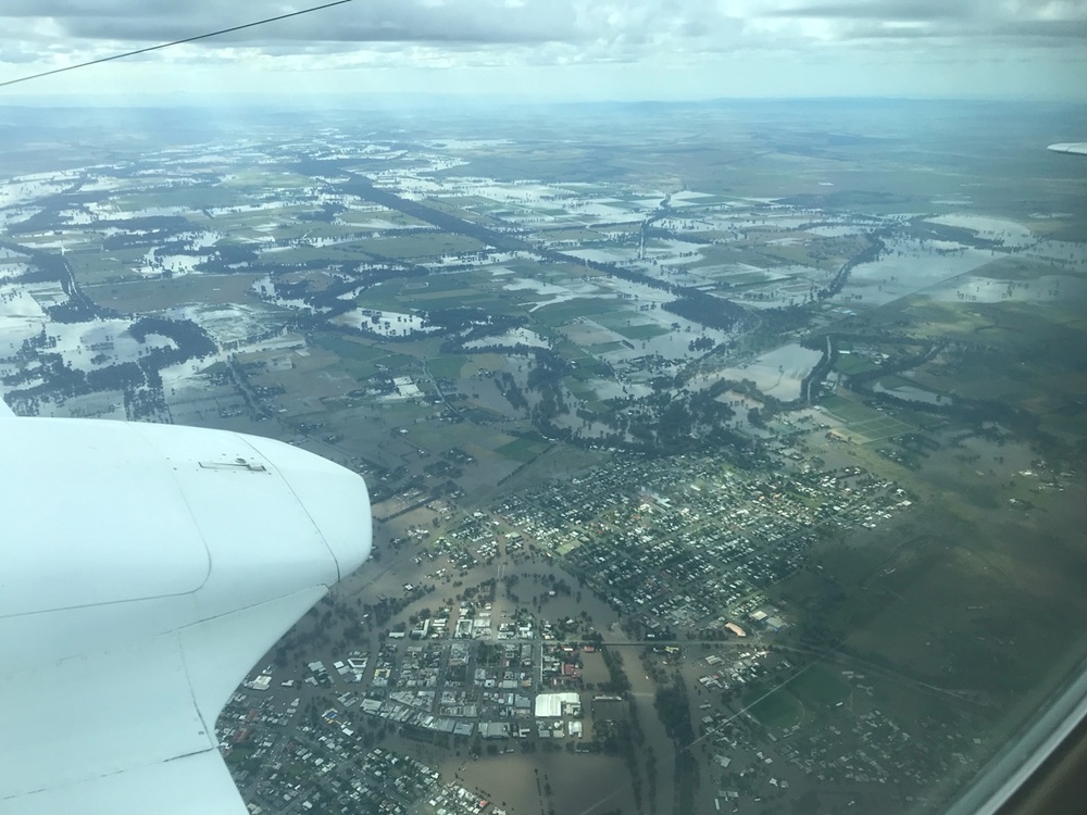
DCS Spatial Services operates two aircraft fitted with Leica sensors—the CityMapper 2 and TerrainMapper 2—to capture imagery during and immediately after disasters. These sensors collect massive volumes of data that emergency services require immediate access to during critical events. Historically, it took up to four days to process aerial imagery and LiDAR data, which hampered timely, informed decision-making.
To address this challenge, DCS Spatial Services launched a project to develop a rapid response imagery and elevation data processing solution. The team needed to overcome several obstacles, including the transfer of large datasets, limitations of legacy IT infrastructure, and the complexity of processing workflows and software systems.
Solution | Enhancing Emergency Response and Data Processing Using AWS
DCS Spatial Services modernized its spatial data infrastructure on AWS, significantly improving processing speed, operational efficiency and data accessibility. The transformation reduced aerial imagery and LiDAR data processing times from four days to under 22 hours—well below the critical 24-hour threshold—helping emergency teams assess damage and coordinate relief efforts faster.
Over a 10-month transformation period, DCS Spatial Services worked with AWS Professional Services and AWS Partner Mantel Group to enhance its cloud capabilities through workshops, architecture reviews, and migration planning. The initiative began with an internal proof of concept that successfully adapted Leica's HxMap software for cloud deployment, making DCS Spatial Services only the second organization globally to achieve cloud-native HxMap processing. The proof validated effectiveness by processing 692 square kilometers of data—roughly the size of Singapore—well ahead of the 24-hour target.
At the same time, DCS Spatial Services was leading a broader AWS Cloud Modernisation initiative. Building on the success of the PoC, DCS Spatial Services worked with AWS Professional Services to turn the prototype into a secure, scalable production system supporting emergency, business-as-usual, and fee-for-service workflows. With Amazon Simple Storage Service (Amazon S3), an object storage service, and pre-signed URLs, DCS Spatial Services made key technical enhancements, including parallel processing, automated infrastructure provisioning, and secure data delivery. Processing speeds improved by over 1,200 percent compared to on-premises systems, with complex tasks accelerating by more than 3,000 percent. Data ingestion time also dropped from 11 hours to just over two—an 80 percent reduction.
As part of the broader modernization initiative, the agency deployed Landing Zone Accelerator on AWS to establish a secure cloud foundation with tagging policies, observability dashboards, and automation frameworks. It also adopted AWS Managed Services (AMS) for automated security incident remediation, streamlined patching and 24/7 infrastructure monitoring, significantly reducing operational overhead. By offloading routine but essential tasks, internal teams can now focus more resources on developing spatial services that benefit NSW citizens.
The agency also deployed several AWS services to enhance scalability, security, and cost efficiency for its spatial data infrastructure. Amazon Aurora PostgreSQL, a fully managed, relational database service, replaced legacy Informix databases, improving data reliability, automated backups, and providing high availability for government-wide access.
DCS Spatial Services also used Amazon EC2 Spot Instances, which offered discounted, on-demand compute capacity to support large-scale spatial data processing at lower costs. The agency also implemented a comprehensive FinOps approach with resource tagging to allow cost-per-job management, providing greater visibility and accountability across different workloads. With this combination of strategies, the agency achieved up to 90 percent in cost savings while maintaining scalability for high-demand workloads.
To improve operational agility, DCS Spatial Services used AWS Service Catalog, a service that centrally manages approved IT resources. With the shift to self-service infrastructure provisioning, teams can now deploy spatial workloads more efficiently and with greater autonomy.
For remote Geographic Information System (GIS) operations, the agency adopted Amazon AppStream 2.0 - a fully managed application streaming service that provides secure, scalable access to desktop applications. By transitioning ArcPro clients to the AWS service, DCS Spatial Services improved remote accessibility for spatial analysts, reducing reliance on physical desktops and on-premises infrastructure.
To strengthen cybersecurity, the agency utilized Amazon Inspector, an automated vulnerability management service. With this solution, DCS Spatial Services significantly improved its compliance posture and resilience against cyber threats.
This foundation enabled rapid modernization while allowing for future innovation.
Outcome | Advancing Spatial Data Innovation in NSW
DCS Spatial Services successfully modernized key spatial data infrastructure with AWS, achieving significant improvements in processing speed, operational agility, and data accessibility. The digital transformation continues with plans to migrate remaining legacy systems to the cloud. The agency is strengthening its financial operations strategy to enhance cost optimization, accountability and long-term cloud investment planning.
By combining internal technical expertise with strategic external collaboration, DCS Spatial Services delivered not just a rapid-response capability but a repeatable, future-ready innovation platform. The project received the DCS Excellence Award for Innovation, setting a new benchmark for public sector agility and performance.
Looking ahead, DCS Spatial Services plans to explore new AWS services to support real-time geospatial analytics, machine learning-driven insights and enhanced disaster response capabilities. By continuing its cloud-first approach, the agency is well-positioned to drive data-driven decision-making across government services and support the evolving needs of NSW communities.
"The project has transformed how we deliver spatial services across New South Wales. We've built a faster, more reliable foundation that empowers government agencies to make informed decisions, respond to emergencies faster, and improve public services. This is just the beginning—we're creating a smarter, more connected future for our state," said Steven Longhurst, Director Information Services at DCS Spatial Services.
The project has transformed how we deliver spatial services across New South Wales. We've built a faster, more reliable foundation that empowers government agencies to make informed decisions, respond to emergencies faster, and improve public services. This is just the beginning—we're creating a smarter, more connected future for our state.
Steven Longhurst
Director Information Services, NSW Department of Customer Service Spatial ServicesAWS Services Used
Did you find what you were looking for today?
Let us know so we can improve the quality of the content on our pages.