AWS Public Sector Blog
Bringing world-class satellite imagery to smallholder farmers with open data
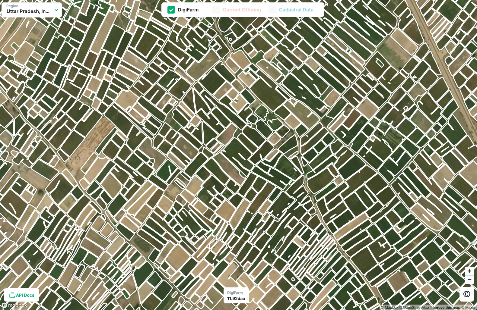 Source: DigiFarm
Precision agriculture, a high-tech version of modern farming, is based on intensive data collection with local-sensor-based technology and remotely-sensed imagery. The goal is to inform the decision-making process for improving crop production and revenue while decreasing environmental impact. The better the quality of data, the better the outcomes of those decisions.
As part of the Amazon Sustainability Data Initiative (ASDI), we invited Nils Helset, co-founder and chief executive officer (CEO) of DigiFarm, to share how Amazon Web Services (AWS) Cloud technology and open data support DigiFarm’s efforts to make agricultural practices more sustainable and efficient.
Sustainable agriculture requires accurate and current data
A fundamental data point in precision agriculture is field boundary data. Field boundaries are the separations between parcels of land by hedges, ditches, or grass margins. Field boundary data is used by government agencies, land management agencies, retailers, banks, insurance providers, and farmers themselves to determine the seeded field acre area boundaries. However, the data on field boundaries and seeded acres, which is managed by national agencies, is often out of date or inaccurate.
For instance, the Norwegian Institute of Bioeconomy Research (NIBIO) maps the biological resources of land, including field boundaries, at a rate of only 100 square kilometers per year. Because of the slow progress of the mapping effort, a lot of the field boundary data in Norway quickly becomes outdated, which can affect billions of euros in annual subsidies. The Land Parcel Identification System (LPIS) of the EU uses aerial and satellite photographs to record land parcels and field boundaries. In 2014, the European Commission found that some EU countries have field boundary records that are over seven years old. In the US, the USDA’s Farm Service Agency (FSA) manages field boundaries, but the 2008 Farm Bill restricted public access to the data and began to require the land owner’s consent to update maps, so most have not been updated since.
If field boundaries and seeded acres data isn’t updated every year, farms can repeatedly waste valuable resources on parcels that don’t produce useful crops. This potential for waste can contribute to additional CO2 emissions and significantly reduce already slim farming margins. Better data-driven decisions, in contrast, can help avoid wasting resources, compensate for seasonal uncertainty, minimize production costs, and increase crop revenue.
Upgrading satellite imagery field detection with deep learning
DigiFarm, a Norwegian agricultural startup established in 2019, is working to bring accurate and up-to-date field boundary data to farmers and government agencies. I am the co-founder and CEO of DigiFarm, as well as a 15th generation farmer, and have spent the majority of my life dedicated to wheat and barley production on my family farm. I intimately understand the agricultural industry and the common challenges of an ordinary farmer.
DigiFarm’s software product is powered by a deep learning model that takes satellite imagery and builds additional, higher-definition layers on top of each geospatial data point. Currently, DigiFarm uses data from the Sentinel-2 satellite constellation, some of the highest-quality imagery of the Earth available today. DigiFarm algorithms enhance the Sentinel-2 data, originally in a 10 meter per pixel resolution, to a staggering 1 meter per pixel resolution. The additional detail enables exceedingly precise field boundary delineation for smaller parcels.
DigiFarm is collaborating with the Norwegian University of Life Sciences (NMBU), Norway’s leading academic center for agricultural technology, agronomy, and biology. NMBU develops the methodology for detecting field boundaries, while DigiFarm has created and now maintains the deep neural network model built on top of it. We have teamed up to detect field boundaries in India, a challenging task due to the country’s multiple growing seasons, multi-crop fields, and the number of smallholder farms that have never been mapped. While these smaller farms are not exactly accounted for in a global market, they are key to their local economies. Recently, DigiFarm and NMBU completed the initial field delineation model training and inference of a region in Uttar Pradesh, India. The area of interest included 10,000 square kilometers, or one million hectares, of agricultural land. Just over 500,000 smallholder field boundaries were detected in this area (see the boundaries in this demo). Farmers in the region can now receive subsidies based on their sustainable agricultural practices, and get access to detailed advice on reducing costs, increasing yield, and getting better prices for their produce.
Open data on AWS supports global field boundary detection at a lower cost
Through the Amazon Sustainability Data Initiative (ASDI) program, DigiFarm can access the Sentinel-2 satellite imagery dataset at no cost in the AWS Cloud. DigiFarm accesses the raw data for Sentinel-2 (L2A) stored in an Amazon Simple Storage Service (Amazon S3) bucket and uses the data to train the main field boundary recognition model. The imagery in the Amazon S3 bucket is refreshed every five days, and the field boundaries that DigiFarm recognizes get updated accordingly. The process to train DigiFarm’s deep learning model is highly reliant on GPU instances and requires powerful—and expensive—equipment. By using Amazon SageMaker with the Amazon Elastic Compute Cloud (Amazon EC2) spot instances, DigiFarm drove their field boundary model training costs down by 70 percent of their pre-cloud cost.
DigiFarm has already delineated over 100 million hectares of field boundaries, with current country-wide coverage in Germany, Italy, Czech Republic, Austria, Belgium, Denmark, Switzerland, and Norway. In 2022, we expect to turn our prototype into a commercial service delivered to businesses and governments in India, Asia-Pacific, and Africa. By being able to access satellite imagery on AWS at no cost, DigiFarm’s affordable service can help more farmers conserve water and fertilizer and make their farms more financially sustainable.
On the government side, DigiFarm’s application enables automatic verification of subsidy applications that dramatically reduces the cost of subsidy administration. The additional visibility into the subsidies also provides a more accurate picture of crop-production and grain-balance across entire regions and allows governments to flag out-of-balance areas ahead of time and take action.
Next steps for the agricultural industry around the globe
Due to its initial success, DigiFarm and NMBU are expanding the project. We will cover additional geographical regions in India: 20 million hectares per month for the next 12 months. Banks and other financial institutions in India are already looking to use the technology as part of the underwriting process for lending, crop insurance, and farm management solutions. DigiFarm can further help smallholders adopt precision agriculture technology that can enable them to improve yield potential and to reduce their input costs, which, according to USDA estimates and DigiFarm’s research, are up to 50 percent of the total crop-production cost. In India specifically, such improvements can catapult smallholder farmers beyond subsistence farming.
DigiFarm has recently acquired clients like KWS, Bayer Crop Science, Agricolus, Auster Tecnologia, and the Norwegian Agricultural Advisory (NLR). We have also worked with the World Wildlife Foundation (WWF) to assess multi-year deforestation in Myanmar, and our results were used in the national government’s policy assessments for sustainable crop production. DigiFarm also has 18 additional pilot projects underway with agribusinesses and government agencies.
ASDI’s resources enable DigiFarm to make its state-of-the-art field-boundary modeling available and enhance decision-making in the agricultural industry in traditionally underserved regions around the world.
Learn more about ASDI here and visit Digifarm’s website for information about their solutions.
Are you interested in learning more about how to use artificial intelligence (AI) and machine learning (ML) for practical use cases in the public sector? Discover more public sector AIML solutions and learn practical skills to start your machine learning journey in this AIML webinar series.
Subscribe to the AWS Public Sector Blog newsletter to get the latest in AWS tools, solutions, and innovations from the public sector delivered to your inbox, or contact us.
Please take a few minutes to share insights regarding your experience with the AWS Public Sector Blog in this survey, and we’ll use feedback from the survey to create more content aligned with the preferences of our readers.