AWS Public Sector Blog
Digital Earth Africa and AWS are making satellite data work for Africa
Africa is changing rapidly. Its land is under pressure from degradation, deforestation, and expanding cities. Its water resources are being stretched by climate variability and growing demand. Its coastlines are shifting because of a combination of sea level rise, erosion, and human activity in ways that threaten communities, infrastructure, and ecosystems. And across all these challenges, governments and practitioners are often making decisions with incomplete, outdated, or inaccessible information.
What is new is the ability to see these changes clearly, at continental scale, in near real time, through Earth observation.
Where it started
In 2019, Digital Earth Africa launched with a simple ambition: to make satellite data work for Africa. Our aim was to create data that is useful, processed, accessible, and ready for the kinds of decisions that governments, researchers, and communities need to make every day.
To do that at continental scale required more than good intentions. It required infrastructure. Amazon Web Services (AWS), through the Open Data on AWS and Amazon Sustainability Data Initiative (ASDI) programs, became a foundational collaborator from the outset, hosting Digital Earth Africa’s data on AWS infrastructure in Cape Town, South Africa, and enabling African users to access and analyze petabytes of satellite data at a speed and scale that would otherwise be out of reach.
Over the last 6 years, that collaboration has grown into something significant. Digital Earth Africa now hosts 11 petabytes of satellite data in the Registry of Open Data, delivering 12 continental-scale services, and supporting a community of more than 38,000 active users across the continent. More than 50 government ministries have benefited from Digital Earth Africa’s tools.
But the numbers only tell part of the story. The more important story is what has been built layer by layer on top of that foundation.
Building the layers
Continental infrastructure is only as valuable as the services it enables. From the outset, Digital Earth Africa set about building those services systematically, each one compounding on the last.
The first major water intelligence layer was Water Observations from Space (WOfS). Drawing on decades of Landsat satellite imagery, WOfS maps where water has been present across the African continent since the mid-1980s. It shows where water is reliably found, where it appears only seasonally, and where it has disappeared entirely over time. Updated continuously as new satellite data becomes available, it gave African governments and researchers something they had never had before: a long-term, continent-wide picture of surface water dynamics, available at no cost and open to anyone who needed it.
From WOfS came the Waterbodies Monitoring Service, tracking the size and surface extent of individual water bodies over time, identifying trends, and flagging changes that signal deeper environmental shifts. And from that came the most recent milestone: the Water Quality Monitoring Service (WQMS), launched earlier this year. For the first time, it’s possible to monitor where water is and what condition it’s in at continental scale, using satellite data, in near real time.
In parallel, Digital Earth Africa built out its Coastlines Monitoring Service, mapping the position of Africa’s shoreline year by year, going back 24 years, tracking erosion and growth at both national and local levels. Like WOfS, it runs on the same AWS hosted infrastructure, and like WOfS, Digital Earth Africa designed it from the outset to be useful to the people making decisions on the ground, not only to researchers.
Each of these services is a layer. Each layer made the next one possible. And the cloud infrastructure that AWS provides is what makes all of them run at continental scale.
The following diagram shows the AWS services and Regions that host Digital Earth Africa’s infrastructure. In the Africa (Cape Town) Region, compute resources include Amazon Elastic Kubernetes Services (Amazon EKS), Amazon Elastic Compute Cloud (Amazon EC2), Amazon Simple Storage Service (Amazon S3), AWS Lambda, Amazon Relational Database Service (Amazon RDS), Amazon Cognito, and Amazon GuardDuty, while storage resources include Amazon S3, Lambda, and Amazon Elastic Container Registry (Amazon ECR). Amazon S3 and AWS Lambda are also used in the Europe (Frankfurt) Region, adding geographic resilience.
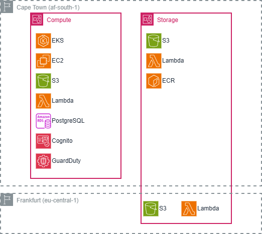
Figure 1: AWS services and Regions used by Digital Earth Africa
What it looks like on the ground
The value of continental infrastructure is ultimately proven at country level in the specific places where data meets decision.
In Botswana, researchers at the Okavango Research Institute used WOfS to monitor Lake Ngami, one of the Okavango Delta’s most ecologically significant water bodies. The satellite record revealed significant changes in water levels over time, changes that would have been difficult to detect and impossible to quantify without decades of consistent observation. That evidence is now informing sustainable management practices for one of Africa’s most important freshwater ecosystems.
In Tanzania, analysts used the WOfS Annual Summary dataset to track changes in the extent of Lake Sulunga in Central Tanzania over time, turning what would otherwise be a labor-intensive field monitoring exercise into a rapid, reproducible analysis available to anyone with an internet connection. The kind of work that at one time required high-end computing infrastructure and months of data processing now takes minutes.
The following architecture diagram shows the AWS services behind the WOfS Landsat data pipeline. Source imagery from USGS triggers Amazon Simple Notification Service (Amazon SNS) messages that pass through an Amazon Simple Queue Service (Amazon SQS) queue and a Lambda function into an S3 bucket for storage. From there, the same pattern of Amazon SNS and Amazon SQS feeds compute resources, including Amazon EKS, Amazon RDS, and Argo Workflows, that turn the raw data into ready-to-use datasets.
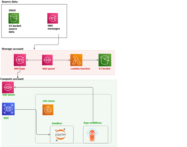
Figure 2: Simplified architecture diagram showing the Landsat data pipeline that supports WOfS
In Senegal, the coastline at Saly Portudal has become one of the most closely studied shorelines on the continent not because it’s unique but because Digital Earth Africa’s Coastlines Service made it possible to study it rigorously and accessibly. During a regional coastal monitoring workshop, technical staff from across West Africa used Saly Portudal as a live case study, learning to combine satellite data with field observations to validate and strengthen national-level coastal monitoring. Participants left calling for more workshops, more training, and deeper integration of the data into national planning processes.
These are the early returns on a long-term infrastructure investment.
The following map shows the coastline at Saly Portudal, Senegal, as mapped by Digital Earth Africa’s Coastlines Service. The overlaid lines trace how the shoreline has shifted across different years, giving coastal monitoring teams a clear, evidence-based record of erosion and shoreline growth to work from.
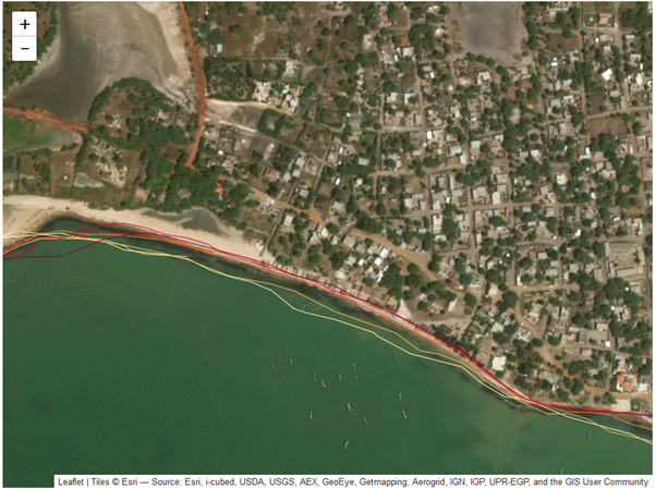
Figure 3: Mapped coastline positions over time at Saly Portudal, Senegal
What becomes possible now
The launch of the WQMS marks a new chapter. Water presence and water condition are different questions, and for much of Africa, the second has been almost impossible to answer at scale. Governments managing reservoirs, utilities monitoring drinking water sources, researchers tracking the health of freshwater ecosystems: all of them have been working with incomplete information.
WQMS changes that. Built on the foundation of WOfS and the Waterbodies Monitoring Service, it brings water quality into the same open, accessible, continental framework that Digital Earth Africa has been building since 2019. The infrastructure was always pointing here.
For AWS, this trajectory reflects something important about what cloud infrastructure can do when it’s genuinely embedded in a program with long-term ambitions. The data has accumulated into something more than merely an archive; it compounds. Each new service builds on what came before. Each new user adds to a community of practice that now spans the continent.
Looking ahead
The maturity of a program is measured not by what it has built, but by what it has made possible for others. By that measure, Digital Earth Africa and AWS are only beginning to see the returns on what they started in 2019.
African universities are incorporating Digital Earth Africa tools into curricula. National governments are embedding satellite data into policy decisions. Researchers are using open data to ask questions that were previously unanswerable. And with each new service, from coastline monitoring to water quality, the foundation becomes more valuable.
Learn more
Visit Digital Earth Africa to explore their open data services and continental monitoring tools. To learn how AWS Open Data supports open science and public sector decision-making, visit the Registry of Open Data on AWS.