AWS for Industries
AWS and Mapbox for Connected Vehicle Data Analytics and Visualization
Mapbox is the platform for location – an AI map built from billions of sensors. Developers use Mapbox APIs and SDKs to add live location into their applications. This includes maps, navigation, and search services to mobile and web applications, logistics networks, and automotive navigation systems. The Mapbox AI-powered AWS Data Pipeline processes over 300 million miles of anonymized and aggregated live road telemetry data daily. This allows Mapbox to continuously update the map everywhere in the world.
AWS and Mapbox can be combined for powerful geospatial analytics and visualization of vehicle data. In this blog, we’ll review a number of ways the AWS Connected Mobility Solution (CMS) can be integrated with Mapbox building blocks for enriching, cleaning, analyzing, and visualizing geospatial vehicle data.
The AWS Connected Mobility Solution
The AWS Connected Mobility Solution (CMS) addresses the automotive industry’s need for scalability, security, and flexibility when connecting products and services for next-generation vehicles. The CMS architecture is designed per AWS best practices and is easily extended to solve a number of problems common to automotive manufacturers and suppliers. The AWS Connected Mobility solution consists of: an edge runtime, an ingestion services layer, a data services layer, an application services layer, a platform API layer, and a front-end layer. Each layer strategically implements key AWS services that work together and can be easily extended with solutions like Mapbox. The AWS Connected Mobility Solution provides a jump-start for use-cases like provisioning and lifecycle management, software updates, secure data consumption, driver behavior, anomaly detection, diagnostics alerts, location-based services, and fleet configuration management.
AWS CMS uses Mapbox with a standard developer token for the new Fleet Management interface. Users are able to locate and visualize vehicles on the map in real time. The extensible architecture of CMS can easily integrate with other Mapbox features as described in the following paragraph to build advanced visualizations and analyze data.
Customizable high-frame rate data visualization
Developers can customize any aspect of a Mapbox map with Studio, including embedding their own data, fonts, imagery, video, and 3D. What’s unique about Mapbox is that data can not only be stylized but accessed live in a web browser, mobile or embedded application. Furthermore, this is possible at virtually unlimited density and scale. For example, Uber utilizes a Mapbox custom map style to visualize hundreds of thousands of taxi pickups and drop-offs in Manhattan over the course of the day. You can see this in the image below and explore the map to see this in action.

Use Mapbox GL and Studio to create a fast interactive visualization at 60 fps.
Mapbox comes with a number of powerful features to facilitate data visualization and analytics. Among them: direct access to the data in the map, Data Driven Styling that uses dynamic data attributes to change the map styling, Runtime Styling for changing the styling of a map programmatically at runtime, and the Mapbox Tiling Service (MTS), an API to turn high density data into fast maps.
Isochrones for analysis and geofencing
Isochrones describe travel times around a point, developers can use them to trigger events whenever a driver enters an isochrone. For instance, an application for shop assistants could use isochrones to trigger a notification whenever a pick-up customer is 5 minutes away from the store location.
With over 225 million miles of real-time telemetry data processed daily, Mapbox provides accurate ETAs and real-world traffic conditions in over 40 countries. With precise drive times, you can identify the best locations for infrastructure, plan for autonomous fleet deployment, analyze commuting patterns, allocation of car-sharing fleets and more.

Real Time boundaries with Mapbox Isochrones API
The example above retrieves drive time boundaries via the Mapbox Isochrones API and visualization them with Mapbox GL JS — showing how far London drivers can travel within a given window. Read the blog post or check out the live demo for more.
Map matching for snapping to road + speed limit detection
The Mapbox Map Matching API cleans up and enriches vehicle GPS traces on the road network—allowing you to create clean visualizations, understand travel frequencies on real-world streets, detect speeding, and more. An example use case could be to detect speed limit infractions by drivers by map matching their GPS traces and comparing actual speed with posted speed limits retrieved through the map matching process.
Map matching produces a rectified route snapped to real-world streets, allowing developers to accurately measure distance or aggregate like routes to measure travel frequency. And enriching the GPS trace with street name information and real-time speeds along the way provides valuable geographic and traffic context.
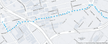
In this image you can see how a raw GPS trace is snapped to the road network for cleanup. In addition to geometry alignment, Map Matching retrieves relevant road metadata like speed limits, and road names for a GPS trace.
Mapbox Vision SDK: AI-based Computer Vision for Safety Alerts
The Mapbox Vision SDK embeds into your vehicles’ or dash cams’ camera and detects safety relevant events and driving relevant features: for example speed limit detections, lane detections, tail gating warnings, and other sign detections. You can ingest this information and surface it in fleet manager dashboards or use it to enrich your own vehicle data such as for instance GPS probe data to understand rolling stop signs. For example, you can embed Vision in their embedded dash cam device or a mobile phone and detect near-collision and speed limit infractions in real time to alert drivers and help them drive safer.

The screenshot shows the Mapbox Vision SDK flagging a near-accident for review.
Add location context with Mapbox Geocoding and Boundaries
You can utilize the Mapbox Geocoding API and Mapbox Boundaries to retrieve the address, administrative name on multiple admin levels, or postal for a location. This is highly useful for providing human readable names in visualizations or for segmenting data into commonly used geographic entities. As a simple example, use reverse geocoding to allow human readable location names in an application (“Car location: 2nd Street”). As an example for boundaries, you can aggregate events like hard breaking events or the density of probe data by commonly understood administrative entities. Or trigger an alert in your application when crossing a state or country border.

Mapbox Boundaries cover Administrative, Legislative, Locality, Postal and Statistical areas globally.
Add activity context with Mapbox Movement
Mapbox Movement is generated from over 600 million anonymized mobile devices and 405,000+ different apps powered by Mapbox. It is designed to understand human activity on an aggregate level. Utilize it to understand where your charging infrastructure needs additional investment, or to normalize your fleets activity levels by utilizing the general activity levels in a geography. Movement comes in a structured flat file dataset delivered daily with an easy to use schema. As an example, you can utilize movement data to understand where to best place EV charging stations or points of sales to maximize traffic.

Mapbox Movement provides an anonymized activity index for the globe.
In this blog, you learned about how AWS CMS uses Mapbox with a standard developer token for the new Fleet Management interface, and how the architecture of CMS can easily integrate with other Mapbox features to build advanced visualizations and analyze data. Get started with Mapbox by signing up for an account with https://account.mapbox.com/auth/signup/.