AWS Public Sector Blog
Tag: datasets
The ERA5 Reanalysis Dataset Provides a Sharper View on Past Weather
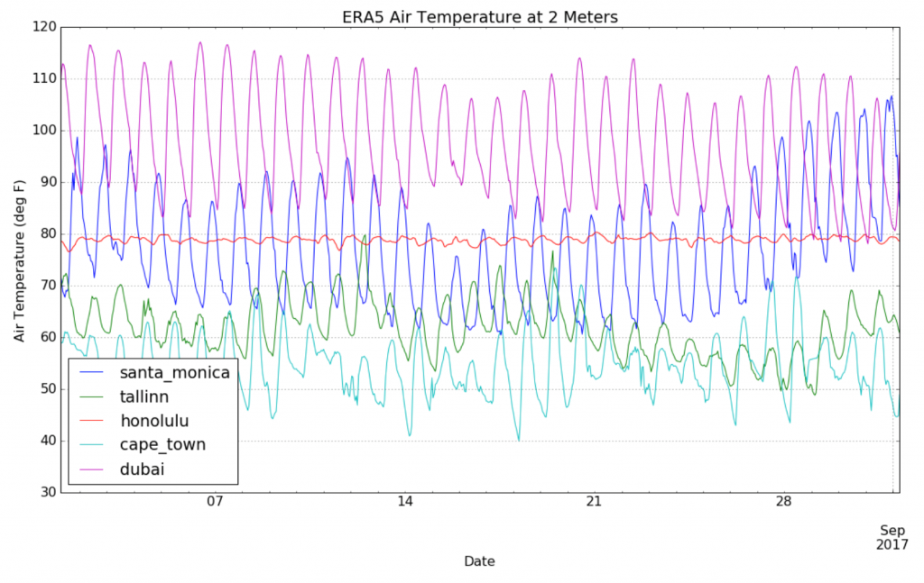
Reanalysis is the term for using modern-day technology to analyze weather data from the past. By doing so, meteorologists and climatologists can produce a more accurate analysis of previous weather conditions, which is important for climate change research. The European Centre of Medium Range Forecasts (ECMWF) is producing its latest reanalysis dataset, called ERA5. Recently, Chris Kalima and his team at Intertrust, in conjunction with the AWS Public Datasets Program, have been working to bring the ERA5 data to AWS.

Q&A: Open990 and How to Access Financial Indicators from Nonprofits
Last year, we shared a post about the Nonprofit Open Data Collective and how a consortium of nonprofits and researchers came together to make the data from the IRS’s 990 filings easier to work with. As a follow-up, we spoke with David Borenstein, one of the driving forces behind the Nonprofit Open Data Collective, about his new project: Open990.

The Opioid Council: Public Health Leaders Address Addiction
To kick off the AWS Opioid Crisis Council’s inaugural meeting, AWS public health leader, Michael Jackson, convened a panel of healthcare experts at the AWS Public Sector Summit in Washington, DC. Government health officials, research scientists, pharmacy executives, and industry pioneers examined proposed solutions with open data, and shared ideas for attacking this complex issue. All stakeholders rallied around a common customer: our community.
The Rise of the Chief Data Officer as a Data Leader
As organizations increasingly rely on data to accomplish their goals, they are adding a new role in order to balance expertise in statistics, policy, management, leadership, and rapidly evolving technology: the chief data officer (CDO). Although individuals with the same set of responsibilities may hold many titles, there has been a rapid growth in the role of the CDO in recent years.

Announcing Registry of Open Data on AWS
We are excited to announce the launch of the Registry of Open Data on AWS (RODA). With RODA, you can find and share data staged publicly for analysis on AWS. Search for datasets by keyword and tags for common types of data, such as genomic, satellite imagery, and transportation, on a simple web interface. Every dataset listed in RODA includes basic information about the data, how to access it on AWS, its license, a link to documentation, and contact information if you have questions. Many listings also include links to tutorials or applications that make use of the data.

70 Datasets Inspire Winning Ideas to Tackle Opioid Crisis
When the team at the U.S. Department of Health and Human Services wanted help addressing the nation’s opioid epidemic, they decided to do something simple – invite in the country’s brightest minds and give them API-enabled, up-to-date data.

Develop and extract value from open data
In this blog post, we explore a use case for government organizations using the OpenStreetMap (OSM) dataset, a free, editable map of the world, created and maintained by volunteers and available for use with an open license. Using open source tools, we generate and render custom maps for a government’s digital property. By leveraging Amazon S3, Amazon EC2, Amazon ECS, and multi-tiered architectures, map tiles server can run in an efficient and highly available infrastructure.

Submit a Proposal for the GBDX for Sustainability Challenge
The United Nations (UN) has named 17 goals that will help boost sustainable development worldwide. Technology and cloud-based solutions will be a critical part of achieving the Global Goals for Sustainable Development (SDGs). DigitalGlobe, one of the world’s leading providers of high-resolution Earth imagery, data and analysis, with support from Amazon Web Services (AWS), has launched the GBDX for Sustainability Challenge. We are looking for passionate participants who can leverage machine learning and high-resolution satellite imagery for geospatial solutions that support these sustainable development goals, such as disaster response, food security, poverty elimination, and ending malaria, to name a few.

The China-Brazil Earth Resources Satellite Mission
The China-Brazil Earth Resources Satellite (CBERS) satellites are the result of a cooperation agreement between Brazilian and Chinese space agencies (INPE and CAST, respectively) started in 1988. Since then, five satellites have launched (CBERS-1/2/2A/3/4).

Ten Big Open Data Stories from 2017
AWS customers did amazing work with open data this year. Here are some of the stories from the year, including releases of massive new datasets, tutorials on how to work with data in the cloud, and stories of how people are using AWS to put open data to work.