AWS Public Sector Blog
Tag: research
EO/GIS Training Lab with On-demand Services from AWS
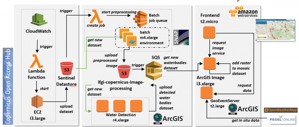
In 2017, a group of students at the Institute for Geoinformatics at the University of Münster embarked on an ambitious project: to build an Earth Observation Infrastructure on AWS that would support disaster preparedness for flooding situations in Europe. We asked Professor Remke about the project, how AWS was used, and his recommendations for similar projects in this Q&A.
The Rise of the Chief Data Officer as a Data Leader
As organizations increasingly rely on data to accomplish their goals, they are adding a new role in order to balance expertise in statistics, policy, management, leadership, and rapidly evolving technology: the chief data officer (CDO). Although individuals with the same set of responsibilities may hold many titles, there has been a rapid growth in the role of the CDO in recent years.

Exploring Earth and Space with the Cloud
Join us for a unique Earth & Space on AWS experience Tuesday, June 19, 2018. Hear from customers and thought leaders who are unearthing new discoveries through cloud technology and public-private partnerships. Choose from nine breakout sessions highlighting innovations with geospatial data, satellite technology, artificial intelligence, machine learning, high-performance computing, and much more.

New Low-Cost Option to Access AWS Direct Connect through Internet2
Using AWS Direct Connect, Internet2 and NET+ members can now establish private connectivity between AWS and their datacenter, office, or colocation environment, which can reduce network costs, increase bandwidth throughput, and provide a more consistent network experience than Internet-based connections. Internet2, a member-owned advanced technology community, provides a collaborative environment for U.S. research and education organizations to solve common technology challenges and to develop innovative solutions in support of their educational, research, and community service missions.

Urban Institute Advances Mission, from Security to Speed to Capacity, with the Cloud
The Urban Institute is a Washington, D.C.-based policy research organization dedicated to developing evidence-based insights that improve decision making, strengthen communities, and make people’s lives better. As a leader in data-driven policy research, the Urban Institute was looking for a solution that would enable it to run sophisticated data analytics and microsimulation models with flexibility, speed, and accuracy.

Faster Genome Search via AWS X-Ray
There are many arguments for building a serverless architecture. Chief among them, users only pay for the computing power they use. Organizations can begin by identifying and eliminating the bottlenecks in their workflow. For example, CSIRO Bioinformatics in Sydney, Australia, used AWS X-Ray to systematically evaluate their serverless architecture and, by doing so, improved their runtime by 80%.

The Boss: A Petascale Database for Large-Scale Neuroscience Powered by Serverless Technologies
The Intelligence Advanced Research Projects Activity (IARPA) Machine Intelligence from Cortical Networks (MICrONS) program seeks to revolutionize machine learning by better understanding the representations, transformations, and learning rules employed by the brain. We spoke with Dean Kleissas, Research Engineer working on the IARPA MICrONS Project at the Johns Hopkins University Applied Physics Laboratory (JHU/APL), and […]
Accessing NOAA’s GOES-R Series Satellite Weather Imagery Data on AWS
Data from the National Oceanic and Atmospheric Administration’s (NOAA) Geostationary Operational Environmental Satellites (GOES)-R series satellite is available on Amazon Simple Storage Service (Amazon S3). Access it here at no cost. NOAA operates a constellation of Geostationary Operational Environmental Satellites to provide continuous weather imagery and monitoring of meteorological and space environment data for the […]
Unlocking Healthcare and Life Sciences Research with AWS
September 8, 2021: Amazon Elasticsearch Service has been renamed to Amazon OpenSearch Service. See details. From introductory material to in-depth architectures, the AWS Public Sector Summit featured sessions relevant to healthcare and life science researchers. The full set of session videos are located here, along with slides to match, but in this post, we will […]
Call for Proposals for the Amazon Research Awards
Amazon has opened a call for proposals for the 2017 round of Amazon Research Awards (ARA) in a number of areas, including machine translation, natural language understanding, search, robotics, and more. The program is open to faculty members at academic institutions in North America and Europe and awards up to 80,000 USD in cash and […]