AWS Public Sector Blog

Author: Daniel Bernao
Daniel Bernao is a senior solutions architect working for the worldwide public sector of AWS in Europe. Specializing in machine learning and artificial intelligence, he is deeply interested in creating technology that can help improve lives.

Automating fall detection with AWS DeepLens
What if someone in a hospital room or public train station suddenly falls due to a stroke or other health issue? An automated monitoring system like AWS DeepLens, a deep learning-enabled video camera for developers, could detect such falls and contact emergency services in a timely manner. Using AWS DeepLens, I created a solution.
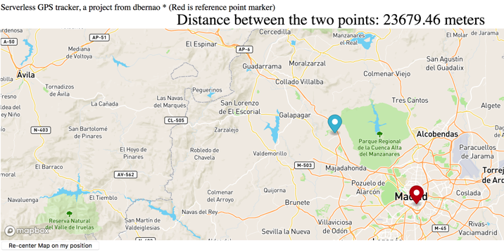
Creating a serverless GPS monitoring and alerting solution
To help solve a few challenges I faced with my family, including the need to track the location of a child, I needed a serverless global positioning system (GPS) monitoring solution. Commercial geographic monitoring GPS solutions are not cost-effective because of the cost of digital map licenses from third parties and running servers around the clock. Existing GPS systems work with proprietary GPS devices that lock-in the users’ vendors’ devices. My solution? Build my own serverless GPS monitoring and alerting solution.
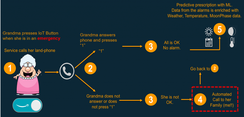
Grandma Emergency Button: A simple emergency alert solution with AWS IoT Button
My grandma is 88-years old with reduced mobility. She lives alone, without a caretaker, in a small village. If she falls, then she is in danger. If something goes wrong when she’s in bed, she might need assistance. With an AWS IoT button, she can call for help in a simple way and potentially save her life. Her village provides free Wi-Fi coverage, so I built an emergency alert system using AWS. When she clicks the AWS IoT button, a series of events will take place to get her the assistance she needs. This can help her in difficult situations. It’s a solution that others can create as well. In this blog post, I’ll show you how to get started.

Develop and extract value from open data
In this blog post, we explore a use case for government organizations using the OpenStreetMap (OSM) dataset, a free, editable map of the world, created and maintained by volunteers and available for use with an open license. Using open source tools, we generate and render custom maps for a government’s digital property. By leveraging Amazon S3, Amazon EC2, Amazon ECS, and multi-tiered architectures, map tiles server can run in an efficient and highly available infrastructure.

Using a serverless architecture to collect and prioritize citizen feedback
Just as companies listen to their customers to align the business with their client needs, government organizations listen to their citizens to improve the citizen experience. In order to get feedback, many organizations use different tools with a multi-channel approach, such as customer comments, Helpdesk calls, emails, social media, or mobile apps. Using Amazon Simple […]