AWS for M&E Blog
Textron systems displays new geospatial analytic tool with AWS at the 2019 GEOINT symposium
Video is often thought of in terms of entertainment, but it also informs decisions across a range of industries, from defense to oil and gas, agriculture, and beyond. Intelligence agencies, for instance, analyze live footage from aircraft to gather and act on timely intel, or in agriculture, footage from an unmanned aerial system (UAS) can be used to evaluate crop yield or fight fires. To support quick and seamless video delivery for various defense, agricultural and industrial applications, solutions provider Textron Systems has released SeeGEO, which can be configured for integration with cloud-based services from Amazon Web Services (AWS). The SeeGEO geospatial analytic platform creates, packages, and delivers live and on-demand aerial footage that gives analysts a bird’s eye view of particular regions of interest.
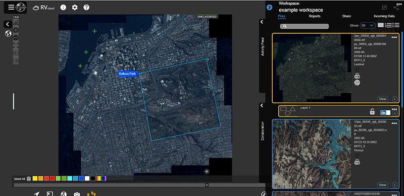
The variant of SeeGEO on-display at GEOINT is configured for integration with AWS cloud-based services, demonstrating a powerful video management system. After SeeGEO ingests and captures live contribution feeds from aerial camera sensor systems, which are then run through AWS Elemental Live to generate Adaptive Bitrate (ABR) streaming profiles of the content. These ABR-formatted streams are then sent to AWS Elemental Delta, where they are packaged and saved as live-to-video-on-demand assets and stored in Amazon Simple Storage Service (Amazon S3), or local storage. All of the AWS tools can be packaged under the SeeGEO interface, which can run in a browser on desktop, laptop, or mobile devices. Once a video asset is created and formatted as an HEVC file to reduce file storage requirements, users can quickly access the video for review and editing. Further, the solution allows users to overlay video and imagery against an integrated mapping component, extract KLV metadata, and generate advanced geospatial products and reports. A platform-agnostic tool, it can be used with AWS Elemental Live, AWS Elemental Server, and AWS Elemental Delta when on-premises or with cloud services like AWS Elemental MediaLive, AWS Elemental MediaConvert, and AWS Elemental MediaPackage.
“We’re helping people use video in a unique way. Rather than distributing it widely to a massive audience like that of a sporting event, our core audience comprises one analyst or a small team that depends on the video to make mission-critical decisions during or after flight,” shared Daryl Madden, Senior Vice President of Geospatial Systems, Textron Systems. “The applications are endless, and with the ability to integrate with AWS, we can rest assured that whatever the use case, our customers will receive the high-quality video they need to make decisions in the field.”
SeeGEO is a trademark of Overwatch Systems Ltd.