AWS for Industries
Accelerating subsurface collaboration with streamlined raster image rendering
OAG Analytics software running on AWS accelerates collaboration between geoscientists and data scientists with seamless interaction of 100+ GB geo-encoded raster images in a web browser or mobile device.
Problem
Large geotagged raster images are frequently used as input data to, and are generated by, hybrid machine learning workflows that quantify subsurface resources like hydrocarbons, copper, gold, and lithium.
These images are a valuable way for data scientists to collaborate with geoscientists and other team members by providing large-scale visualizations to help de-risk prospects and improve exploration efficiency.
However, due to the size and resolution of these large-scale images, rapidly rending them for collaborative processes is a challenge. Individual files are frequently over 100 GB in size and full interaction is needed from these images via a range of end user devices to effectively improve workflow outcomes.
Geoscientists from both oil and gas, and mining teams have reached out to OAG Analytics to create a new tool that enabled them to rapidly review large geotagged raster images that are used to inform machine learning models and are generated by our analytics workflows.
These customers had multiple desktop and web-based tools that could load geotagged raster images, however the legacy tools struggled with rapidly loading large (100+ GB) images, resulting in substantial delays in providing SME feedback to the data science team.
Solution
OAG has developed an intelligent image caching solution to deliver these large-scale image files with the smoothness and responsiveness of a satellite map layer being displayed on a mobile application. Deployment of this solution with data scientists and other subsurface professionals has resulted in feedback time being reduced by over 20 minutes per iteration.
Architecture
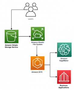
Broadly, files are uploaded by users to an Amazon Simple Storage Service, or S3 bucket, which provides durable and scalable object storage for staging raw data. From there, Amazon Elastic File System (Amazon EFS) is used for high-throughput shared file storage, which allows integration with Amazon Elastic Container Service (Amazon ECS).
The raster image rendering solution, like all other solutions currently offered at OAG Analytics, is based around a containerized deployment of modules Kubernetes, which allows for integration with existing and custom analytics packages, as well as a modularized environment for customers to have maximum flexibility with deployment options. Integration also exists with Amazon SageMaker, AWS Marketplace, and other business applications like TIBCO Spotfire.
Results
Following implementation of the “Raster Image Server” solution on AWS, both oil & gas and mining customers reported reducing cycle time to review a completed analysis from over 30 minutes to under 10, enabling these teams to more than double their analytics productivity.
By designing and deploying on AWS, OAG reduced our R&D costs for this capability by over 27% and shortened the release to production timeline 18% faster than if we were deploying on-premises.
Call to Action
OAG’s hybrid machine learning solutions deliver rapid innovation through extensible tools that deploy as standalone applications or integrate with your data science workflows.
The Geo Raster Image Server is the latest addition to this portfolio and accelerates quantifying subsurface resources. OAG’s extensible Geo Raster Image Server is available for immediate deployment and will also be available on the AWS Marketplace in Q3-2020.
https://OAGanalytics.com, insights@OAGanalytics.com
About OAG Analytics OAG Analytics, headquartered in Houston, is a leading data science provider to oil & gas and mining companies. OAG runs on Amazon Web Services (AWS) and is a TIBCO Spotfire ISV Velocity Partner.