AWS Public Sector Blog
Tag: Amazon Sustainability Data Initiative

How the cloud is helping us better understand and manage the oceans
The world’s waters are largely unknown, with vast areas still unmapped. To protect and preserve the oceans, we need to extensively understand its systems, and data is at the core of that process. The Amazon Sustainability Data Initiative (ASDI) is committed to enabling better access to the foundational data that can help researchers, businesses, and policy-makers better monitor and manage the ocean’s valuable resources.

Open data on AWS supports sustainable agricultural practices and crop optimization
With a rapidly growing population, the world is increasingly dependent on the ability to develop and maintain sustainable agriculture and healthy environments. Learn how BASF Digital Farming is leveraging both National Oceanic and Atmospheric Administration (NOAA) weather data hosted on AWS, and commercial weather data, to develop digital solutions to help farmers effectively monitor and manage their fields, and help drive farm sustainability.

Collecting data in remote oceans with a cost-efficient, scalable, and flexible infrastructure
Saildrone builds and operates a fleet of unmanned surface vehicles (USVs) designed to collect high-resolution oceanographic and atmospheric data in remote oceans. Known as saildrones, each vehicle can stay at sea for up to 12 months, transmitting real-time data via satellite. The data collected is used to inform climate models and extreme weather prediction, maritime domain awareness, maps and charts, and sustainable management of resources. Using clean, renewable wind and solar power, saildrones provide access to the world’s oceans at a fraction of the cost of traditional ship-based methods, while drastically reducing the carbon footprint of global ocean observation.

Addressing environmental challenges with the AWS Cloud
Azavea believes in the power of geospatial technology to improve communities and the planet. Azavea has been exploring the power of this technology to help their clients to answer complex questions in a wide range of domains from urban ecosystems, infrastructure planning, and economic development to water, energy, and climate change. As part of the Amazon Sustainability Data Initiative (ASDI), we invited Jessica Cahail, product manager at Azavea, to share how her organization is using AWS and open data to develop tools that help users address environmental challenges and deliver knowledge to support decision making.

Driving sustainability through youth engagement
Today, speakers at the 24th World Scout Jamboree (WSJ) will introduce nano, a new gamified app developed on the Amazon Web Services (AWS) Cloud that encourages youth around the world to adopt daily sustainability practices to help improve our planet. The Scouts are also launching #ScoutsRecycle, a campaign that leverages the nano app for sustainability. Through nano, scouts will be able to measure the impact of their efforts by calculating the CO2e emissions avoided through #ScoutsRecycle.

Embracing the cloud for climate research
Scientists at NC State University’s North Carolina Institute for Climate Studies (NCICS) work with large datasets and complex computational analysis. Traditionally, they did their work using on-premises computational resources. As different projects were stretching the limits of those systems, NCICS decided to explore cloud computing. As part of the Amazon Sustainability Data Initiative, we invited Jessica Mathews, Jared Rennie, and Tom Maycock to share what they learned from using AWS for climate research. As they considered exploring the cloud to support their work, the idea of leaving the comfort of the local environment was a bit scary. And they had questions: How much will it cost? What does it take to deploy processing to the cloud? Will it be faster? Will the results match what they were getting with their own systems? Here is their story and what they learned.

Earth Science Information Partners: Promoting innovation for Earth science data
The Earth Science Information Partners (ESIP) is a US-based nonprofit organization funded by NASA, NOAA, and the USGS. ESIP is playing a critical role in facilitating collaborative efforts to improve the collection, stewardship, and use of Earth science data and information. As part of the Amazon Sustainability Data Initiative, we invited Dr. Annie Burgess, ESIP Lab Director, to share the story of how ESIP is advancing knowledge of Earth-system science.

Announcing Cloud Grants to Improve Understanding of Our Planet
The Group on Earth Observations (GEO) announced the 21 projects from 17 developing countries that will be awarded $1.5 million USD worth of cloud services, grants, and technical support through the Earth Observation Cloud Credits Programme. Under the Amazon Sustainability Data Initiative (ASDI), this programme will enable Earth observations and applications to support sustainable environmental development including the United Nations Sustainable Development Goals, the Sendai Framework for Disaster Risk Reduction, and the Paris Agreement on Climate Change.

Geo-Diverse Open Training Data as a Global Public Good
Radiant Earth Foundation is a nonprofit focused on delivering open geospatial data and analytics to the global development community (GDC) in support of their missions to address the Sustainable Development Goals (SDGs) and other key targets. Radiant Earth supports GDC by aggregating open geospatial data and providing access through its cloud-based platform, generating open Earth Observation (EO) machine learning tools and training data libraries, and creating new metadata standards through its MLHub Earth initiative. Additionally, the organization offers training resources to support capacity development and expertise in the geospatial and remote sensing sciences.
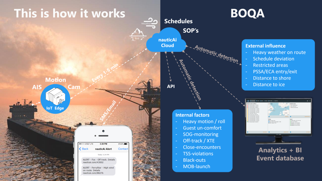
Maritime Operations – Automating Operational Quality Assurance with AWS and Open Data
nauticAi is a maritime startup from Finland, specializing in affordable intelligent awareness solutions for ship operators. The company’s BOQA-solution (Bridge Operations Quality Assurance) automates the Operational Quality Assurance of maritime operations with proven methods from the flight industry. A few key components in their solution include open weather data from NOAA and Finnish FMI, Internet of Things (IoT) technology, and a serverless AWS architecture using AWS Lambda and Amazon Aurora. As part of the Amazon Sustainability Data Initiative, we invited Capt. Henrik Ramm-Schmidt, CEO and founder of nauticAi, to share the story of nauticAi with us.