AWS Public Sector Blog
Tag: OpenStreetMap

Querying the Daylight OpenStreetMap Distribution with Amazon Athena
In 2020, Meta introduced the Daylight Map Distribution, which combines OpenStreetMap (OSM) data with quality and consistency checks from Daylight mapping partners to create a no-cost, stable, and simple-to-use global map. This blog post provides a brief overview of OSM and Daylight followed by a step-by-step tutorial using five real-world examples. We combine the powerful query capabilities of Amazon Athena from with the feature-rich Daylight OSM data to demonstrate a typical OSM data analysis workflow.

How AWS is supporting nonprofits, governments, and communities impacted by Hurricane Ian
On September 28, 2022, Hurricane Ian made landfall in Southwest Florida. At the request of standby organizations Help.NGO and Information Technology Disaster Resource Center (ITDRC), the AWS Disaster Preparedness and Response team assisted with response operations across a variety of functions in the aftermath of Hurricane Ian.

NUS Urban Analytics Lab scales research globally with AWS
The Urban Analytics Lab at the National University of Singapore (NUS) spearheads research in geospatial data analysis and 3D city modelling. The lab’s work underpins the development of smart cities and provides scientists, architects, urban planners, and real estate developers with data insights. These insights help parties make informed decisions about projects ranging from energy modelling to urban farming. To meet rising global demand for its data analytics and planning tools, Urban Analytics Lab turned to Amazon Web Services (AWS).

Serverless GIS with Amazon S3, open data, and ArcGIS
If you are hosting an ArcGIS web app today, then you are probably hosting it on a Windows or Linux server using traditional web server software like IIS or Apache. With the web hosting capability of Amazon S3 you can remove the need to run these servers and the maintenance, management, and monitoring overhead that comes with it. Serverless services like Amazon S3 can scale automatically and can be as simple as copying over your website assets to get up and running in minutes. This blog focuses on web app implementations using ArcGIS API for JavaScript (as other ArcGIS web apps have additional considerations).
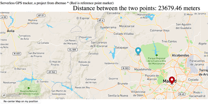
Creating a serverless GPS monitoring and alerting solution
To help solve a few challenges I faced with my family, including the need to track the location of a child, I needed a serverless global positioning system (GPS) monitoring solution. Commercial geographic monitoring GPS solutions are not cost-effective because of the cost of digital map licenses from third parties and running servers around the clock. Existing GPS systems work with proprietary GPS devices that lock-in the users’ vendors’ devices. My solution? Build my own serverless GPS monitoring and alerting solution.

Develop and extract value from open data
In this blog post, we explore a use case for government organizations using the OpenStreetMap (OSM) dataset, a free, editable map of the world, created and maintained by volunteers and available for use with an open license. Using open source tools, we generate and render custom maps for a government’s digital property. By leveraging Amazon S3, Amazon EC2, Amazon ECS, and multi-tiered architectures, map tiles server can run in an efficient and highly available infrastructure.