AWS Public Sector Blog
Category: Sustainability
The road to zero waste: Driving efficiencies in sustainability with cloud technology
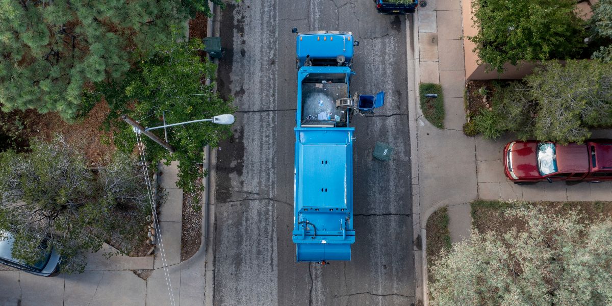
The new four-part documentary series Climate Next from Amazon explores how governments and organizations around the world use cloud technology from Amazon Web Services (AWS) to drive innovation in response to our changing planet, create scalable solutions to address climate change, and empower communities to protect and preserve our planet. One episode of the series showcases how the City of Santa Fe, New Mexico uses cloud technology to create a more efficient waste and recycling management operation to divert waste from landfills and reduce greenhouse gas emissions.

Cloud powers faster, greener, and more collaborative research, according to new IDC report
According to a new IDC report, the cloud is helping researchers conduct research faster than ever before by reducing data analysis and processing times, and is allowing researchers around the world to collaborate on solving universal problems. In addition to the positive impact on research, IDC also forecasts that continued adoption of cloud computing globally could prevent environmental emission of more than 1 billion metric tons of CO2 from 2021 through 2024, almost equivalent to removing the 2020 CO2 emissions of Germany and the U.K. combined.
Dive deep into sustainability with the re:Invent sustainability attendee guide
This year’s re:Invent includes many sustainability topics. To guide you across breakout sessions and activities, check out the re:Invent sustainability attendee guide. We’re looking forward to sharing this content to inspire teams, to learn from each other, to get hands-on, and to see what’s possible when we combine technology with sustainability.

AWS hosts new open dataset to help businesses identify climate finance risks and investments
Companies and asset managers looking to protect their financial investments from climate change-related risks, and invest in more sustainable solutions, can now access a new dataset on the Amazon Web Services (AWS) Cloud to help inform their decision making. Amazon announced that the Legal Entity Identifier (LEI) dataset is now available and free for anyone to access in the cloud. The dataset includes key reference information that supports clear and unique identification of legal entities participating in financial transactions, and each LEI contains information about an entity’s ownership structure, including ‘who is who’ and ‘who owns whom’.

Why moving to the cloud should be part of your sustainability strategy
A recent report by 451 Research, part of S&P Global Market Intelligence, commissioned by the Amazon Web Services (AWS) Institute, reveals that moving enterprise and public sector IT workloads from on-premises data centers to the cloud can reduce energy consumption and associated carbon emissions by nearly 80%, and is five times more energy efficient than the typical on-premises Asia Pacific (APAC) data center.

Immediate steps that Asia-Pacific governments can take to decarbonize via the cloud
At AWS, we see cloud computing as enabling accelerated innovation on the path to net zero carbon. That is why we recently hosted our first public webinar on Meeting Sustainability and Climate Goals with the Cloud in APAC, bringing together industry, government, and other key stakeholders, and featuring experts from 451 Research, Environment Resource Management, Intel, Singapore’s Economic Development Board, and AWS customers DBS Bank and Canva. Here are four overarching lessons for APAC policymakers.

AWS in Virginia: The economic impact of solar
This week at Amazon Web Services (AWS) Summit Washington, DC, we announced the findings of a 10-year economic study about AWS’s presence in Virginia. The report shows the impact that can happen when government and industry work together to create growth opportunities for communities. One component of this that is worth re-highlighting is the positive impact that Amazon solar investments are having and will have on the local economy in Virginia.

UC Davis CWEE accelerates water conservation research with secure, compliant data storage on AWS
To solve some of the most pressing water and energy challenges, scientists and engineers need access to robust, reliable data that is often sensitive and protected. Data providers, researchers, and host institutions need to adhere to strict requirements for protecting and securing this data. The Center for Water-Energy Efficiency (CWEE) at the University of California, Davis (UC Davis) used AWS to create a centralized, secure data repository that streamlines data sharing.

How open data from weather radar helps scientists improve environmental understanding
Weather radars see more than just the weather: they see smoke from fires, meteors, birds, mayflies, and almost anything else in the atmosphere. This makes weather radars an invaluable tool for scientists seeking to further the understanding of atmospheric processes and anything else that happens to be flying through the radar’s field of view. The Amazon Sustainability Data Initiative (ASDI) seeks to accelerate sustainability-related innovation and research by helping to minimizing the cost and time required to store, acquire, and analyze large weather and climate datasets.

Satellite imagery over Africa, a large-scale climate ensemble, and product listings with 3D renderings: The latest open data on AWS
The AWS Open Data Sponsorship Program makes high-value, cloud-optimized datasets publicly available on AWS. This quarter, we released 44 new or updated datasets including satellite imagery over Africa, a large-scale climate ensemble, and product listings with 3D renderings. Learn how you can put these open datasets to work.