AWS Public Sector Blog
Communicating a national flood risk assessment using AWS
The First Street Foundation is a nonprofit research and technology group committed to defining America’s flood risk. Building upon modern modeling techniques validated through peer-review science, the foundation’s team of data scientists, modelers, and researchers have calculated the past, present, and future flood risk of every home and property in the contiguous United States (CONUS). As of today, the public now has access to the data free of charge through Flood Factor™, an online tool that makes it easy to learn about a property’s flood risk.
As part of the Amazon Sustainability Data Initiative (ASDI), we invited Ed Kearns, chief data officer at First Street Foundation, and Mike Amodeo, director of data science at First Street Foundation, to share how their organization is using Amazon Web Services (AWS) and open data to help communicate the importance of a national flood risk assessment.
Flood risk and climate science
The First Street Foundation is dedicated to communicating the flood and inundation risks posed by a changing environment, with an emphasis on allowing Americans to discover and understand those risks. By building awareness, our hope is that every individual is empowered to take steps to reduce their risk exposure to flooding, as well as that of their communities—today and in the future.
First Street created a nationwide assessment of flood risk for the contiguous United States (CONUS), and is now sharing that assessment through Flood Factor™. Flood Factor provides risk scores for each of the approximately 142 million properties in CONUS. Each score was built using open data from the National Oceanic and Atmospheric Administration (NOAA), the United States Geological Survey (USGS), the US Army Corps of Engineers (USACE), and the Federal Emergency Management Agency (FEMA).
This data has been used by First Street to drive hydrologic models by Fathom, coastal storm models by the Rhodium Group and Dr. Kerry Emmanuel of MIT, and historical flooding recreations by the iFlood Lab at George Mason University. Risk factors from rivers, precipitation, sea level rise, and coastal storms have been combined into a single risk assessment methodology based on today’s environmental conditions, as well as future climate conditions simulated following the Intergovernmental Panel on Climate Change’s Representative Concentration Pathway 4.5 assumptions.
The resulting Flood Factor score is a numeric aggregate risk assessment score on a scale from 1 (minimal) to 10 (extreme) for each individual property. It’s calculated based on the probability of the property flooding and the severity of that flooding. Scores for today’s flood risk—and for the risk to be expected until the year 2050—have been calculated taking into account environmental and the flood protection and adaptation features, such as levees and pumps, instituted by local communities. These scores are accompanied by explanations of that risk and suggestions of ways that a property owner can mitigate their risk.
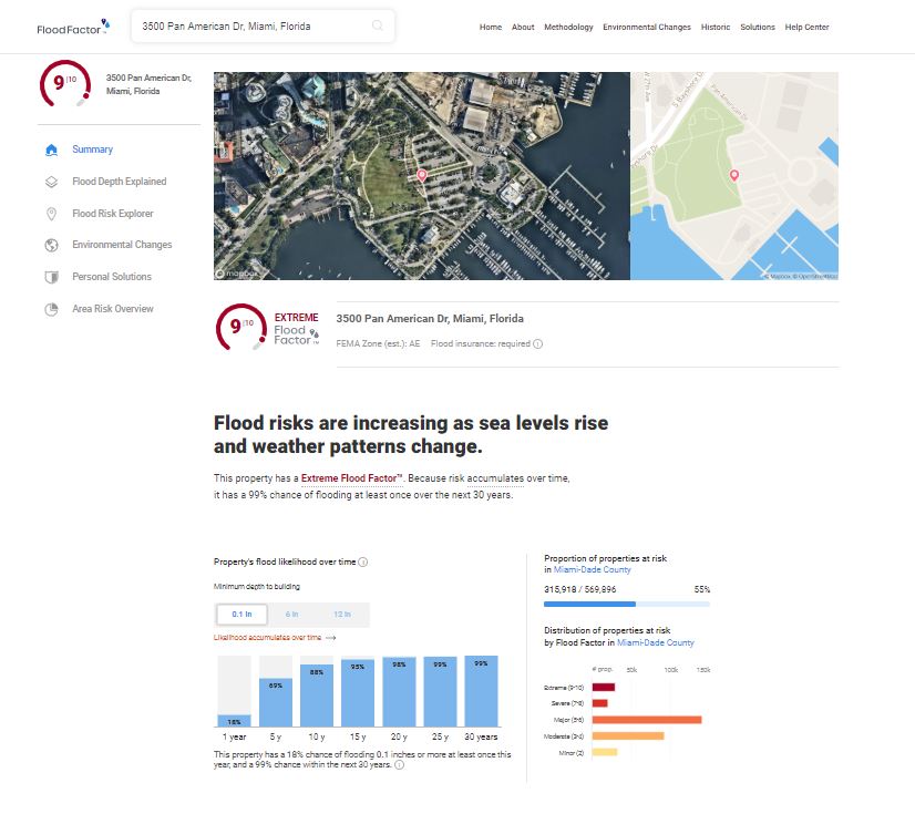
FloodFactor.com provides an individualized flood risk estimate for each of the 142 million properties in the contiguous United States, and includes an estimate of present and future flood as a score between 1 (minimal) to 10 (extreme). (Shown: estimate for City Hall for the City of Miami, FL)
Delivering risk assessments at scale
Assembling the information necessary for individual assessments for every property in CONUS was made possible by the flexible infrastructure available on the Amazon Web Services (AWS) Cloud. Databases were maintained within Amazon Relational Database Service (Amazon RDS) for PostgreSQL, and analyses were conducted using Amazon Elastic Compute Cloud (Amazon EC2). Cloud-optimized GeoTIFFS for visualization and analysis were stored and made accessible through Amazon Simple Storage Service (Amazon S3), which was used to share information internationally among our modeling partners. Flood Factor uses Amazon CloudWatch, Amazon ElasticSearch Service, and Amazon CloudFront among other services to deliver the flood risk information to the public. The ability for First Street Foundation, a small nonprofit organization, to use AWS to easily scale up from simple proof-of-concept studies to a complex national-scale assessment was a key to our success.

Percent increase between years 2020 and 2050 in flood risk due to climate changes, based on First Street’s risk estimates using downscaled data from the IPCC CMIP5 models under the RCP 4.5 assumptions.
To maximize the impact of First Street’s flood risk data and enable us to take action to reduce our collective risk exposure, we need data to be instantly available, easily usable, and readily turned from information to knowledge. To help us accomplish this goal, we established the Flood Lab, a group of over 90 researchers from 20 different institutions who are prepared to dive into the flood data and understand their implications for our economy, local communities, real estate markets, public infrastructure investments, insurance and reinsurance, and more. These researchers have a high level of access to First Street services and data to enable their analyses and build new knowledge. Through the First Street API—also hosted on AWS—researchers can access these services and data from wherever they are at any time. First Street is also providing access to data at scale for commercial use through licensing agreements, ensuring that the value of the data may be realized by industry as well.
First Street welcomes feedback from users of our data. We will be building that feedback into future improvements of our model and information products to continue to provide accurate and actionable flood risk assessments to the American public.
Learn more about the First Street Foundation and the Amazon Sustainability Data Initiative (ASDI).
The content and opinions in this post are those of the third-party author and AWS is not responsible for the content or accuracy of this post.